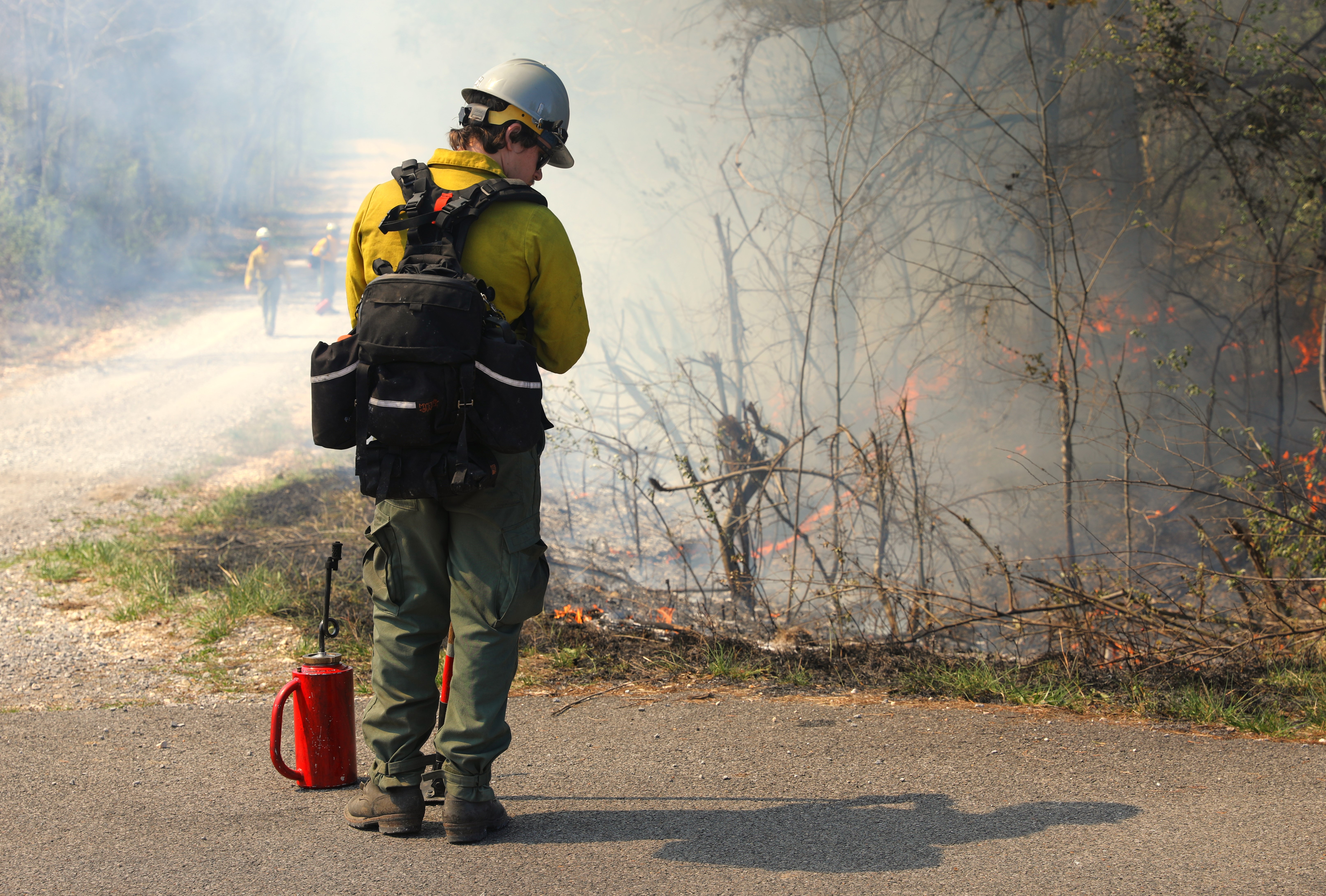
A firefighter monitors the flames of a prescribed burn on Land Between the Lakes National Recreation Area in Ky., March 17, 2024. The 2500-acre burn was lit to improve wildlife habitat and reduce understory growth which prevents desired trees from growing. (Forest Service photo)
Where there’s smoke, there’s fire. Communities surrounding Land Between the Lakes (LBL) National Recreation Area have seen a lot of smoke this winter and early spring. That’s because LBL’s fire crews have been hard at work, taking advantage of good weather to help protect natural resources on LBL with prescribed fire.
“Land Between the Lakes has been blessed with favorable conditions and talented crews to burn more acres than ever before on LBL,” said Jim McCoy, area supervisor at LBL. “We have improved the health of our forests and benefitted the land and recreation opportunities on more than 15,500 acres. I could not be prouder of our staff.”
In addition to the historic number of total acres burned, crews conducted the largest single prescribed burn on LBL March 18, when they put fire to more than 4,500 acres. The burn, along the Woodlands Trace in the southern end of LBL, was lit both by hand crews and by helicopter to maintain and restore forest composition.
Prescribed burns across Kentucky have helped meet a variety of forest health objectives such as removing ground clutter, improving wildlife habitat and reducing understory growth, which is allowing more sunlight to reach the forest floor and promoting the growth of desired trees like white oaks.
These burns were conducted at a time when the commonwealth saw the most acres treated with prescribed fire than any other time in recent memory. Roughly 30,000 acres of Kentucky’s public lands were improved with fire across multiple boundaries including federal, state and local agencies in the last month.
Having favorable conditions as well as the required resources has provided LBL the opportunity to expand on the number of acres treated. In recent years, conditions did not allow for as much burning. For example, 2022 was a drought year with unfavorable conditions for using fire to manage natural resources at LBL. Availability of trained staff also plays a key role in the number of acres that can be managed through prescribed fire.
The more acres of land also equals more smoke in the air. Numerous parameters are considered prior to every burn, including wind patterns and local air quality indexes.
“The decision to ignite a burn must meet predetermined guidelines for every prescribed burn,” said Russell Harris, LBL’s fire management officer. “Planning for burns begins months in advance to ensure attainable objectives and to mitigate the impacts to our visitors and neighboring communities. We take every aspect of our jobs very seriously.”
Smoke modeling is an important factor in prescribed burn planning. The day prior to the planned burn, managers provide location and time of ignition data, along with fuel types, to regional smoke management staff who upload the information into several smoke modeling programs. These programs provide an hourly forecast of where the smoke will travel on the day of the burn. Additionally, local burn managers use several smoke modeling programs to compare local data with the regionally-provided data. The goal of their projections is to help avoid impacts to communities for long durations.
As part of the 10-year National Wildfire Crisis Strategy, Forest Service units are expected to increase their prescribed burning by as much as 20% nationally. LBL and other Southern Region forests also support the strategy by training Western forest crews on prescribed fire. This year, crews from Montana’s Helena National Forest and a Bureau of Land Management crew from Wyoming learned from and assisted LBL staff on recent burns.
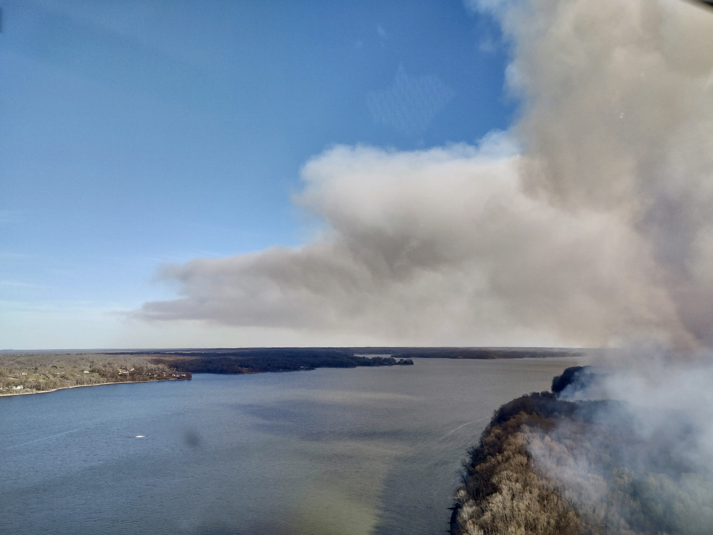
Smoke from a prescribed burn on Land Between the Lakes National Recreation Area drifts across Lake Barkley and Lyon County, Ky., March 17, 2024. Extensive smoke modeling is used prior to every prescribed burn to determine the path of smoke and to help mitigate the impacts to local communities downwind of burns. (Forest Service photo)